Research
In many regions of the world, groundwater is the most important source of drinking water and increasingly relevant for agriculture and industry. Ecosystems such as wetlands, rivers or lakes are also dependent on groundwater. As a hydrogeologist I develop methods to simulate and analyse groundwater systems. I am particularly interested in the conclusions that can be drawn from changes in water quantity and quality at springs and drilled groundwater observation wells.
Groundwater and Climate Change
Assessing the effects of climate change and direct human intervention on the quality and quantity of groundwater and distinguishing them from natural influences is particularly difficult. Above all, indirect effects, such as climate-related changes in vegetation or land use, pose particular challenges. To tackle these challenges I combine hydrogeological methods of groundwater research with approaches from other disciplines and cooperate with partners from various research fields.
Within two completed projects funded by the Earth System Sciences (ESS) programme of the Austrian Academy of Sciences (ÖAW), we cooperated with agricultural and biological research as well as with actors active in water management and agriculture: The project Integrative Groundwater Assessment investigated how groundwater systems in an alpine and prealpine environment respond to extreme hydrological events such as droughts or floods in terms of water quantity and chemical quality as well as ecological status (final report available here); the project ClimGrassHydro aimed to understand how the ecohydrology of mountain grassland and thus groundwater recharge is affected by the individual and combined effects of climate warming, severe drought and elevated atmospheric CO2 concentration (final report available here). The Doctoral Programme Climate Change, funded by the Austrian Science Fund FWF, involved collaboration with even more research fields inlcuding physical climate science, meteorology and hydrology, climate and environmental economics, innovation and sustainability research, normative theory, and environmental law.
Karst Aquifers
Karst aquifers develop where the dissolution of soluble rocks such as limestone and gypsum causes a widening of fractures, thus creating highly conductive solution conduits and caves. The karst conduit system, however, occupies only a small portion of the total aquifer porosity. The vast majority of storage is provided by not substantially widened fissures (i.e., narrow fractures) and/or by the porous rock matrix. Karst aquifers represent important water resources, supplying drinking water for an estimated quarter of the world's population. Effective protection and sustainable use of karst waters require knowledge about aquifer properties relevant to flow and solute transport.
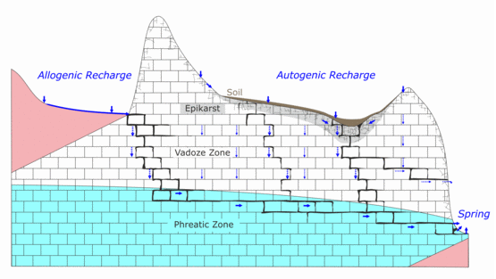
Hydrogeological Characterisation of Karst Catchments
Despite their extreme heterogeneity karst aquifers offer one advantage over unconsolidated materials regarding the aquifer characterisation. Karst groundwater commonly resurfaces at a single spring or a limited group of springs. Thus, water discharging from a karst spring carries an imprint of the entire spring catchment. This makes it possible to infer aquifer properties from observations at the karst spring (e.g., time series of discharge, specific conductance and temperature of the discharged water). A methodology for an improved characterisation of karst aquifers was developed and tested within the project "Process-based characterisation of the dual flow and transport properties of karst aquifers" funded by the German Research Foundation (DFG) (final report in german ~ 2 MB). The approach is based on a combined analysis of spring hydrographs and artificial and natural tracers (e.g., Birk et al. 2004, 2005, 2006, 2010, Geyer et al. 2007, 2008, Hergarten and Birk, 2007). These methods were also employed, amongst others, to identify and characterise intercatchment flow at the Lurbach-Schmelzbach-Hammerbach karst system near Graz (e.g., Wagner et al. 2011, Birk et al. 2014).
Evolution of Karst Aquifers
The relation between hydrogeological environment and the evolution of conduits in soluble rocks can be examined by numerical modelling. Until recently, such numerical models had mainly been applied to generic conceptual settings. In contrast, the completed DFG project "Void evolution in soluble rocks: Development and validation of numerical models by field evidence" (final report) aimed to establish site-related numerical models based on field data compiled from selected study sites in the deep-seated settings of the Western Ukraine. To this end, the coupled continuum-pipe flow model CAVE, representing the fractured porous rock by a continuum approach and the solution conduits by a discrete pipe network, was employed ( Rehrl et al. 2008, 2010). Within the completed FWF project "Transport characteristics as imprint of karst evolution" the evolution of conduits was examined more generally, focussing on the frequency distributions of the conduit apertures and the resulting transport properties of the karst aquifers (Hubinger and Birk 2011).
Groundwater Modelling in Karst Terrains
Groundwater modelling has become a standard technique regularly applied, e.g., for engineering tasks and water management purposes in porous aquifers. In the above mentioned work specific modelling tools, such as the coupled continuum-pipe flow model CAVE, were developed to account for the peculiarities of karst aquifers. Yet these state-of-the art models are frequently applied for basic research into karst evolution as well as flow and transport phenomena in karst terrains but rarely used for practical purposes. To bridge the gap between research tools such as CAVE and the needs of practioners working in karst areas the Conduit Flow Process CFP was implemented in the well-known USGS flow model MODFLOW (Shoemaker et al. 2008). CFP can be run in mode 1, which is an enhanced version of the hybrid flow model implemented in CAVE, as a single continuum model (mode 2), which mimics turbulent flow by adjusting the hydraulic conductivity of the cells depending on the Reynolds number (e.g., Reimann et al. 2011), or as a combination of both (mode 3). The completed FWF translational research project "Groundwater modelling in karst terrains" aimed to compare and evaluate these different modelling approaches, in particular, with respect to their practical applicability.
Univ.-Prof. Dr.rer.nat.
 Institut für Erdwissenschaften
Steffen Birk
Institut für Erdwissenschaften
